|
Introduction
In researching this section
it was necessary to visit the Castleshaw area, which must be
one of the most beautiful parts of 'old' Yorkshire. This area
remains unspoiled and not yet discovered by tourists, unlike
Holmfirth. (See the Graveship of Holme pages). For this reason
it has been decided to include a selection of photographs to
help take you back to the time of the early middle ages, one
thousand years after the departure of the Romans.
This has been achieved by illustrating a circular walk starting
from Delph and taking in Roebuck Low, Standedge and the Castleshaw
Roman Fort (site of), illustrated with photographs.
This area is on the borders of Cheshire, Derbyshire and the West
Riding of Yorkshire.  . The route
of the walk is shown on the map of the area as it was in Roman
times . The route
of the walk is shown on the map of the area as it was in Roman
times  . .
The first part of the walk can also be followed on the 1850's
map. 
To see larger versions of the photos, click on the thumbnails.
The Walk
This is a circular walk of
about 10 miles starting and finishing at Delph and taking in
some of the most stunning Yorkshire scenery. There is a convenient
car park next to the River Tame, at the foot of the very steep
Knott Hill 
From the car park take the footpath along the Eastern side of
Knott Hill, leading to the farm at Hill Top where the path meets
Hill Top Lane  From this path are magnificent
views of the Pennines including Castleshaw valley to the North
East From this path are magnificent
views of the Pennines including Castleshaw valley to the North
East 
Continue along the ridge towards
Badger Edge, taking Four Acres Lane to Badger Edge Lane 
Following Badger Edge Lane and Shilo Lane takes you to the road
junction on which the Roebuck Inn is located  As this is shown on the 1850's map, the original building is
at least 150 years old. This has since been extended to the side
and more recently to the rear to provide a restaurant.
As this is shown on the 1850's map, the original building is
at least 150 years old. This has since been extended to the side
and more recently to the rear to provide a restaurant.
Roebuck Lane takes you to Roebuck Low Brook and the village,
comprising only about half a dozen dwellings 
Continuing past Luke Lane head leads to the Medlock valley and
to the footpath across the fields and up Roebuck Low, the hill
 At the top of the Hill is an impressive early 20th century monument
 Even more impressive are the views: to the South East can be
seen the high peaks of the Derbyshire Peak District; to the South
West can be seen the plain of Cheshire, the radio telescope of
Jodrel Bank and the Welsh Mountains beyond; to the West you can
look over the sprawling city of Manchester to the coast; to the
North and North West you can see the Pennines continuing as far
as the mountains of the Cumbrian Lake District; and to the Northeast
you can see the Pennines of the West Riding of Yorkshire with
Standedge rising high above the Castleshaw valley
Even more impressive are the views: to the South East can be
seen the high peaks of the Derbyshire Peak District; to the South
West can be seen the plain of Cheshire, the radio telescope of
Jodrel Bank and the Welsh Mountains beyond; to the West you can
look over the sprawling city of Manchester to the coast; to the
North and North West you can see the Pennines continuing as far
as the mountains of the Cumbrian Lake District; and to the Northeast
you can see the Pennines of the West Riding of Yorkshire with
Standedge rising high above the Castleshaw valley 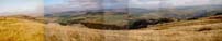
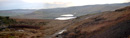
Descending from Roebuck Low to the North East takes you down
some steep slopes and into the valley of the River Tame, which
flows from Denshaw to Delph and Uppermill 
The route now continues off the North side of the map, rising
steeply up the other side of the Tame valley to a place called
Heights. This comprises a farm, a pub and a church and overlooks
the Castleshaw valley to the East 
Continuing from Heights along Broad Lane, which runs North East
along the top of the ridge, which also overlooks Castleshaw valley
and takes you onto Castleshaw Moor and the summit of the Pennines
 .
From here are magnificent views, back over Castleshaw Valley .
From here are magnificent views, back over Castleshaw Valley
 and forward into Yorkshire. The castle rebuilt by the Victorians
at Almondbury is clearly visible as is the television transmitter
sited at Roydhouse, Shelley
and forward into Yorkshire. The castle rebuilt by the Victorians
at Almondbury is clearly visible as is the television transmitter
sited at Roydhouse, Shelley 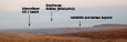 With the aid of binoculars
it is even possible to make out York Minster about 50 miles to
the North East. One of the most striking features, which becomes
obvious from here is the location of the Castleshaw valley. It
is a 'lost' valley completely surrounded by steep sided hills
and ridges. With the aid of binoculars
it is even possible to make out York Minster about 50 miles to
the North East. One of the most striking features, which becomes
obvious from here is the location of the Castleshaw valley. It
is a 'lost' valley completely surrounded by steep sided hills
and ridges.
The route continues along Standedge, overlooking the Castleshaw
valley, before descending along some old lanes down to Bleak
Hey Nook and then further down the steep slopes of Harrop Edge
to the site of the Roman Fort at Castleshaw. These old lanes
actually follow the route of the old Roman Roads leading from
Castleshaw and ascending the Pennines  and might also be the route followed by the traveller from Roebuck
Low who arrived in Netherthong around 1200 BC.
and might also be the route followed by the traveller from Roebuck
Low who arrived in Netherthong around 1200 BC.
The actual site of the Roman Fort is little more than a level
section of field on top of a hillock not far from the Upper reservoir

From Castleshaw Fort, it is an easy walk down the valley and
back into Delph. |
The copyright of this website 2002 to 2008 belongs to the web owner. No part of this website may be sold, used for commercial
purposes or republished in any form, either in print, electronically
or otherwise, without the express permission of the web owner.
Any person, company or organisation found to be in breach of
the foregoing will be liable to prosecution.  |