
|
To see larger versions of the photographs, just click on the thumb nails. The town of Darton and the village of Haigh, including Bretton Hall and the course of the River Dearne can be seen on the old map which dates from about 1854. There are also links from this map to the various photographs. |
|
|
The walk starts at the station
Going under the railway bridge
South towards the river you pass the Park on your right Just over the bridge At the end of the road on the
right hand corner is the 'old' Vicarage built in 1716 Across the road from the Vicarage
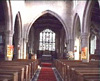
is the magnificent Parish Church of All Saints Mr Percy Featherstone has kindly
donated some more photos of the interior of the Church. From the Churchyard looking North
you can, however, still see the hill of Staincross Across the road you pass the
'modern' Council Offices Going up the hill towards Kexbrough
you soon cross the busy M1 motorway Walking up the hill you get good
views over Darton, the Church and Staincross A public footpath from High Hoyland,
to the right takes you across the fields and down to Bretton
Hall, with its Sculpture Park and two lakes This takes you to the village
of Haigh. Before arriving at Haigh, a nice surprising discovery,
is a grand old Well, hidden in an overgrown quarry The footpath from Bretton Park
soon emerges on Jebb Lane at the village of Haigh. A short distance
up the hill is Haigh Hall From Haigh the walk follows the
river downstream (towards Darton), on the other side of the M1
motorway. The footpath follows the course of the river, between
the river and the railway. Along its banks is evidence of the
past. The river here is fast flowing and there are ruins of what
would have been watermills and bridges. This is the last leg
of the walk which brings you back into the village of Darton
through the Park The walk, itself is about 7 miles in length, but the farthest point of the walk from Darton Parish Church is High Hoyland, which is only about two and a half miles up hill towards the pennines. The village of Haigh is only about 1 mile upstream. The source of the River Dearne is near Denby, in the Pennines on the edge of the ancient graveship of Holme and marked on the Graveship map. In the 17th century, this area would have been woodland, rich in flora and fauna including wild boar and deer. Today, refreshments are available, ready cooked, at pubs in Darton, High Hoyland and the 'Post Office' now an Inn just off the M1 motorway junction 38 at Haigh situated between the old and new villages, and not forgetting the award-winning fish and chip shop at the side of the road in Kexbrough (very difficult for hungry walkers to walk past). |
|
|
|
|
|
The copyright of this website 2002 to 2008 belongs to the web owner. No part of this website may be sold, used for commercial
purposes or republished in any form, either in print, electronically
or otherwise, without the express permission of the web owner.
Any person, company or organisation found to be in breach of
the foregoing will be liable to prosecution. |